Great Ocean Road V/Line Services new timetable effective 1 December 2024


In addition to the Geelong, Bellarine and Surfcoast services, McHarry’s also operates the V/Line bus service along the Great Ocean Road between Geelong and Apollo Bay via Waurn Ponds, Torquay and Lorne.

Please note the 9:05pm Friday outbound service from Geelong will not travel via Waurn Ponds.   This services arrives at Lorne at 10:53pm.  This service will then return to Geelong, departing Lorne at 11:18pm, stopping in Torquay at Bell St at Munday St (Park Lane), before continuing as a Route 53 service to Geelong, arriving at 1:09am Saturday.

You can read more information about the changes on the  V/Line Website.

Please click here to view the new Geelong to Apollo Bay timetable on V/Line website.

If you are just traveling between Geelong and Torquay, then you might like to also see the Route 52 – Jan Juc to Marshall  and Route 53 – Geelong to Torquay Bell St services.

Click arrows to move around the map and zoom in and out.

The blue buses are the time point locations as per the timetable.  They may not be the only bus stops available on this service.

Stop Locations

Fare Prices and Information

Regional Fare increase 1 January 2025.

Victorian Public Transport fares are increasing from 1 January 2025.  The daily full fare has increased to $11.00, or $5.50 for concessions.

Please see the table below for new fares from 1 January 2025.

For further information about the regional fares, visit click here to visit the V/Line site.

Further information can be found at Public Transport Victoria

Where possible please purchase your ticket at Geelong Station, or either the Lorne and Apollo Bay Visitor Information Centres. This speeds up the boarding process.

Tickets can be purchased from the driver but only CASH can be accepted, EFTPOS or credit card facilities ARE NOT available at present.

At this stage, myki can only used between Jan Juc and Geelong.

PLEASE SEE THE TABLE BELOW FOR FARES FROM 1 JANUARY 2025

Weekly tickets are available – see driver for details

Daily tickets are double the single price up to the following fare caps

Weekday fares capped at $11 full fare and $5.50 concession per day.

Weekend and Public Holiday fares capped at $7.60 full fare and $3.80 concession per day.

Full= Full Fare,  Con=Concession

From 1st January, 2025

APOLLO BAY SKENES CREEK KENNETT RIVER WYE RIVER LORNE EASTERN VIEW FAIRHAVEN AIREYS INLET PT R.KNIGHT A’SEA BELLBRAE TORQUAY / JAN JUC / BELLS BEACH T/O MOUNT DUNEED
MELBOURNE Full 11.00 11.00 11.00 11.00 11.00 11.00 11.00 11.00 11.00 11.00 11.00 11.00 11.00
Con 5.50 5.50 5.50 5.50 5.50 5.50 5.50 5.50 5.50 5.50 5.50 5.50 5.50
GEELONG Full 11.00 11.00 11.00 11.00 11.00 11.00 11.00 11.00 7.80 7.80 5.60 3.80 3.00
Con 5.50 5.50 5.50 5.50 5.50 5.50 5.50 5.50 3.90 3.90 2.80 1.90 1.50
MOUNT DUNEED Full 11.00 11.00 11.00 11.00 11.00 9.40 9.40 9.40 6.40 6.40 3.80 3.00 X
Con 5.50 5.50 5.50 5.50 5.50 4.70 4.70 4.70 3.20 3.20 1.90 1.50 X
TORQUAY / JAN JUC / Full 11.00 11.00 11.00 11.00 11.00 7.80 7.80 7.80 5.60 5.60 3.80 3.00 3.00
Con 5.50 5.50 5.50 5.50 5.50 3.90 3.90 3.90 2.80 2.80 1.90 1.50 1.50
BELLBRAE Full 11.00 11.00 11.00 11.00 7.80 5.60 5.60 5.60 3.80 3.80
Con 5.50 5.50 5.50 5.50 3.90 2.80 2.80 2.80 1.90 1.90
ANGLESEA Full 11.00 11.00 9.40 7.80 6.40 4.20 3.80 3.80 3.00 3.00
Con 5.50 5.50 4.70 3.90 3.20 2.10 1.90 1.90 1.50 1.50
PT. ROADKNIGHT Full 11.00 11.00 9.40 7.80 6.40 4.20 3.80 3.80
Con 5.50 5.50 4.70 3.90 3.20 2.10 1.90 1.90
AIREYS INLET Full 11.00 7.80 6.40 5.60 4.20 3.00 3.00 3.00
Con 5.50 3.90 3.20 2.80 2.10 1.50 1.50 1.50
FAIRHAVEN Full 11.00 7.80 6.40 5.60 4.20 3.00
Con 5.50 3.90 3.20 2.80 2.10 1.50
EASTERN VIEW Full 9.40 7.80 6.40 5.60 3.80
Con 4.50 3.90 3.20 2.80 1.90
LORNE Full 6.40 5.60 4.20 3.80 3.00
Con 3.20 2.80 2.10 1.90 1.50
WYE RIVER Full 5.60 3.80 3.00
Con 2.80 1.90 1.50
KENNETT RIVER Full 4.20 3.00
Con 2.10 1.50
SKENES CREEK Full 3.80
Con 1.90
APOLLO BAY Full 3.00
Con 1.50

 
 amampmpm
Apollo Bay 25:519:46....3:06
Apollo Bay 15:539:48....3:08
Skenes Creek5:569:51....3:11
Kennett River6:1610:11....3:31
Wye River6:2110:16....3:36
Lorne Hotel Inbound6:4110:361:303:56
Lorne Main Street Inbound6:5110:511:374:11
Eastern View7:0611:081:544:28
Fairhaven7:0911:111:574:31
Aireys Inlet 2 Inbound7:1211:142:004:34
Aireys Inlet 1 Inbound7:1411:162:024:36
Pt Roadknight Inbound7:2011:232:094:43
Anglesea 2 Inbound7:2311:262:124:46
Anglesea Shops Camp Rd7:2611:312:164:51
Bellbrae 3 Jarosite Road Inbound7:3411:392:244:59
Bellbrae 2 Addiscott Road7:3611:412:265:01
Bellbrae 1 School Road Inbound7:3811:432:285:03
Bells Beach T/O7:3911:442:295:04
Jan Juc Duffields & Ocean Rds Inbound7:4111:462:305:06
Torquay Hol Park Inbound7:4411:492:335:09
Grossmans & Torquay Rds Inbound7:4611:512:355:11
Surf Coast Hwy & Merrijig Drive7:4811:532:375:13
Mt Duneed Rd Surf Coast Hwy7:5211:572:415:17
Pioneer Rd at Surf Coast Hwy 7:5712:032:475:22
Waurn Ponds SC east bound8:0312:082:525:28
Belmont Coles near Strand Arcade8:1012:152:595:38
Geelong City Malop Street8:2512:323:125:54
Geelong Station8:3512:403:206:00
 
 amampmpm
Apollo Bay 26:369:46....4:28
Apollo Bay 16:389:48....4:31
Skenes Creek6:419:51....4:35
Kennett River7:0110:11....4:55
Wye River7:0610:16....5:01
Lorne Hotel Inbound7:2610:411:305:24
Lorne Main Street Inbound7:3610:511:375:37
Eastern View7:5111:081:545:50
Fairhaven7:5411:111:575:53
Aireys Inlet 2 Inbound7:5711:142:005:56
Aireys Inlet 1 Inbound7:5911:162:025:58
Pt Roadknight Inbound8:0511:232:096:06
Anglesea 2 Inbound8:0811:262:126:09
Anglesea Shops Camp Rd8:1111:312:166:16
Bellbrae 3 Jarosite Road Inbound8:1911:392:246:23
Bellbrae 2 Addiscott Road8:2111:412:266:24
Bellbrae 1 School Road Inbound8:2311:432:286:26
Bells Beach T/O8:2411:442:296:28
Jan Juc Duffields & Ocean Rds Inbound8:2611:462:306:31
Torquay Hol Park Inbound8:2911:492:336:35
Grossmans & Torquay Rds Inbound8:3111:512:356:37
Surf Coast Hwy & Merrijig Drive8:3311:532:376:39
Mt Duneed Rd Surf Coast Hwy8:3711:572:416:44
Pioneer Rd at Surf Coast Hwy 8:4212:032:476:49
Waurn Ponds SC east bound8:4812:082:526:54
Belmont Coles near Strand Arcade8:5512:152:597:02
Geelong City Malop Street9:1012:323:127:09
Geelong Station9:2012:403:207:12
 
 amampmpmFri pm
Apollo Bay 25:519:46....2:40
Apollo Bay 15:539:48....2:42
Skenes Creek5:569:51....2:45
Kennett River6:1610:11....3:05
Wye River6:2110:16....3:10
Lorne Hotel Inbound6:4110:361:253:3011:18
Lorne Main Street Inbound6:5110:511:323:4511:23
Eastern View7:0611:081:494:0211:36
Fairhaven7:0911:111:524:0511:39
Aireys Inlet 2 Inbound7:1211:141:554:0811:42
Aireys Inlet 1 Inbound7:1411:161:574:1011:46
Pt Roadknight Inbound7:2011:232:044:1711:57
Anglesea 2 Inbound7:2311:262:074:200:01
Anglesea Shops Camp Rd7:2611:312:114:250:02
Bellbrae 3 Jarosite Road Inbound7:3411:392:194:330:10
Bellbrae 2 Addiscott Road7:3611:412:214:350:12
Bellbrae 1 School Road Inbound7:3811:432:234:370:14
Bells Beach T/O7:3911:442:244:380:16
Jan Juc Duffields & Ocean Rds Inbound7:4111:462:254:400:18
Torquay Hol Park Inbound7:4411:492:284:430:20
Grossmans & Torquay Rds Inbound7:4611:512:304:450:22
Surf Coast Hwy & Merrijig Drive7:4811:532:324:47
Mt Duneed Rd Surf Coast Hwy7:5211:572:364:510:47
Pioneer Rd at Surf Coast Hwy 7:5712:032:424:57
Waurn Ponds SC east bound8:0312:082:475:02
Belmont Coles near Strand Arcade8:1012:152:545:120:58
Geelong City Malop Street8:2512:323:075:281:07
Geelong Station8:3512:403:155:341:09

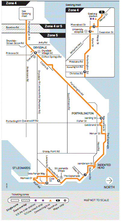
Route Map


Major Stops


Description of route


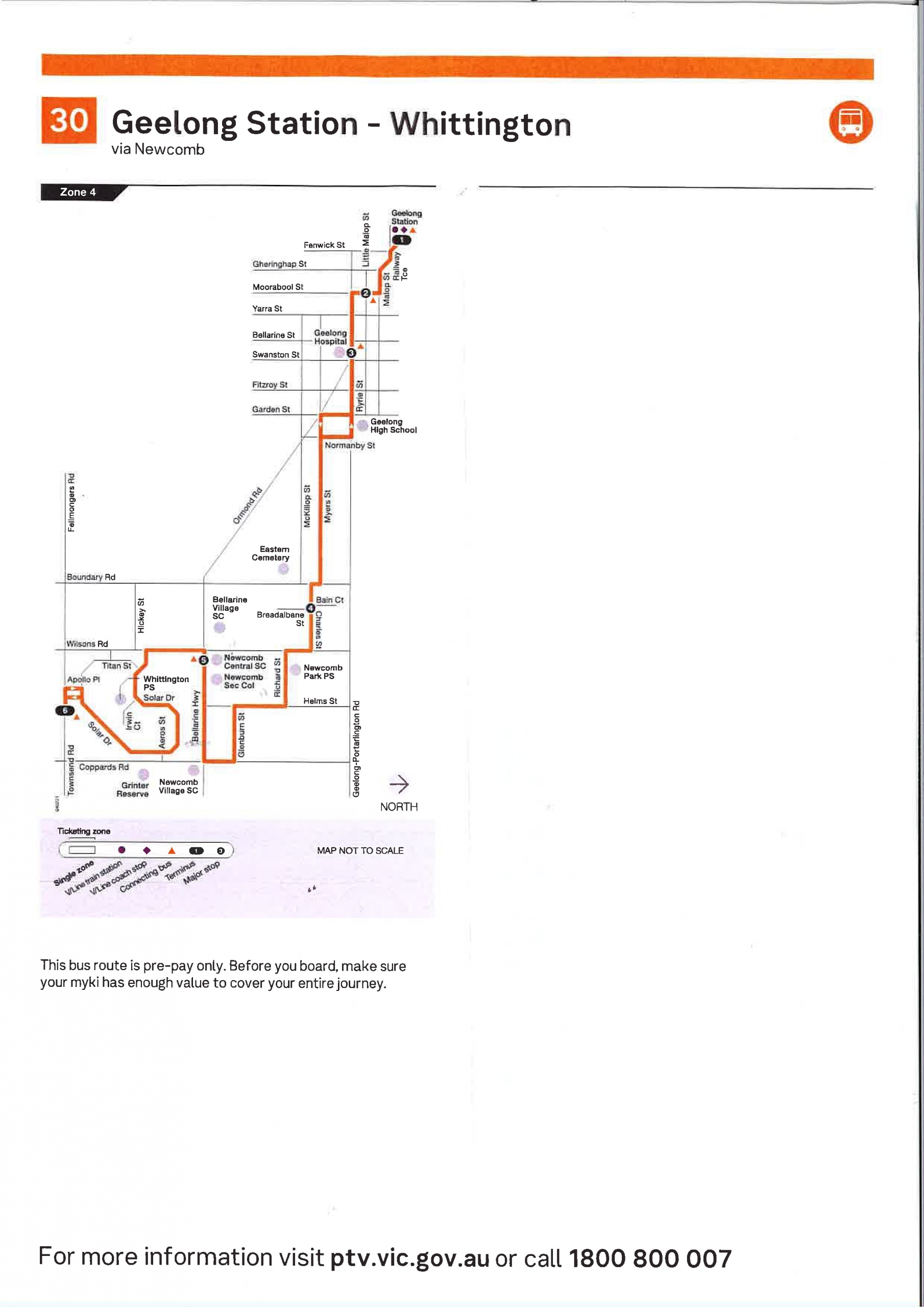
Route 30 – Geelong to Whittington

Departs from Geelong Station and runs via Railway Tce, Mercer St, Malop St, Moorabool St, Ryrie St, Garden St, Myers St, Boundary Rd, Charles St, Wilsons Rd, Richard St, Helms St, Glenburn St, Coppards Rd, Queenscliff Rd (Bellarine Hwy), Wilsons Rd, Solar Dr, Apollo Pl to the terminus in Townsend Rd, Whittington.

PLEASE NOTE: From Whittington Route 30 continues as Route 31 to Geelong.


Route 30 – Whittington to Geelong

Departs from Whittington and runs via Townsend Rd, Apollo Pl, Solar Dr, Wilsons Rd, Queenscliff Rd, Coppards Rd, Glenburn St, Helms St, Richard St, Wilsons Rd, Charles St, Boundary Rd, Myers St, Normanby St, Ryrie St, Moorabool St, Malop St, Mercer St and Railway Tce to Geelong Station.


Route 30 travels between Geelong and Whittington via Newcomb. All services continue onto Route 31 – Geelong to St Albans Park via St Albans Rd where customers will not need to change buses. Route 60 – Geelong to St Leonards via Drysdale & Portarlington is also in the area along Portarlington Rd.

Train Timetables


V/Line operate the train services between Melbourne and Geelong. The above link will open their web site in a new page. To find the Geelong train timetable, go to the timetables section.


Customers please note


Customers Tips

When using our services, we want you to be safe. Here are some tips that may assist you in making your trip more enjoyable.


  • Customer information tools

    There is a range of handy mobile and online tools available to help you access public transport information wherever you are in Victoria

  • Bus Safety

    There are a number of things that you can do to make your bus journey safer and more secure.

  • Travelling with Children

    Public transport is a fun and easy way to travel around Geelong with children. Children aged four years and under travel for free right across Victoria.
    When travelling with a pram, hold on to the pram and make sure your child is strapped in securely. Apply the brake to prevent it from rolling.

 amamamamamamam
Townsend @ Apollo Pl West Bnd5:516:206:416:587:187:467:59
Newcomb Central5:596:286:497:067:267:568:09
Charles St @ Breadalbane St6:066:356:567:137:348:058:18
Geelong Station @ Bay 116:176:467:087:257:498:198:34
        
amamamamamamam
Townsend @ Apollo Pl West Bnd8:268:489:129:339:5510:3111:07
Newcomb Central8:348:579:219:4110:0310:3911:15
Charles St @ Breadalbane St8:439:069:299:4810:1110:4711:23
Geelong Station @ Bay 118:589:209:4310:0310:2511:0311:37
        
ampmpmpmpmpmpm
Townsend @ Apollo Pl West Bnd11:4012:261:151:552:323:033:25
Newcomb Central11:4812:351:232:032:413:123:34
Charles St @ Breadalbane St11:5612:421:312:112:493:203:41
Geelong Station @ Bay 1112:1012:571:452:253:033:353:55
        
pmpmpmpmpmpmpm
Townsend @ Apollo Pl West Bnd3:524:114:294:505:115:305:49
Newcomb Central4:004:194:374:575:195:375:55
Charles St @ Breadalbane St4:084:274:445:045:275:446:03
Geelong Station @ Bay 114:214:414:595:195:405:576:16
        
pmpmpmpmpmpmpm
Townsend @ Apollo Pl West Bnd6:186:276:527:107:278:158:50
Newcomb Central6:256:346:597:177:348:228:57
Charles St @ Breadalbane St6:326:417:248:299:04
Geelong Station @ Bay 116:446:537:368:409:15
        
pm
Townsend @ Apollo Pl West Bnd9:47
Newcomb Central9:54
Charles St @ Breadalbane St
Geelong Station @ Bay 11
 amamamamampmpm
Townsend @ Apollo Pl West Bnd6:548:138:5610:1011:0812:121:35
Newcomb Central7:028:219:0410:1811:1712:201:44
Charles St @ Breadalbane St7:098:299:1210:2611:2412:281:52
Geelong Station @ Bay 117:198:409:2410:4011:3712:422:04
        
 pmpmpmpmpm
Townsend @ Apollo Pl West Bnd2:453:354:545:386:43
Newcomb Central2:533:435:025:466:50
Charles St @ Breadalbane St3:003:505:095:53
Geelong Station @ Bay 113:134:035:206:04
 
 amamampmpmpmpm
Townsend @ Apollo Pl West Bnd8:5610:0111:0212:121:332:423:32
Newcomb Central9:0410:0911:1012:201:412:503:40
Charles St @ Breadalbane St9:1210:1711:1812:271:492:573:47
Geelong Station @ Bay 119:2310:3011:3012:412:013:103:58
        
 
 pmpm
Townsend @ Apollo Pl West Bnd4:545:48
Newcomb Central5:025:55
Charles St @ Breadalbane St5:09
Geelong Station @ Bay 115:20

Route Map


Latest News


Major Stops


Description of route


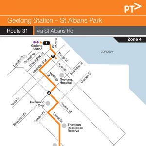
Route 31 – Geelong to St Albans Park

Departs from Geelong Station and runs via Railway Tce, Mercer St, Malop St, Moorabool St, McKillop St, Swanston St, Kilgour St, Garden St, Verner St, St Albans Rd, Townsend Rd, Wilsons Rd, Woods Rd, Homestead Dr, Paramount Cr, Aldershot Rd, Coppards Rd and Townsend Rd to the terminus in Townsend Rd at Apollo Pl, Whittington.


Route 31 – St Albans Park to Geelong

Departs from Townsend Rd and runs via Townsend Rd, Coppards Rd, Aldershot Rd, Paramount Cr, Homestead Dr, Woods Rd, Wilsons Rd, Townsend Rd, St Albans Rd, Verner St, Garden St, Kilgour St, Swanston St, McKillop St, Moorabool St, Malop St, Mercer St and Railway Tce to Geelong Station.


Route 31 travels between Geelong and St Albans Park via St Albans Rd. All services continue onto Route 30 – Geelong to Whittington via Newcomb where customers will not need to change buses. Route 40 – Geelong to Deakin University via Breakwater is also in the area.

Train Timetables


V/Line operate the train services between Melbourne and Geelong. The above link will open their web site in a new page. To find the Geelong train timetable, go to the timetables section.


Customers please note


Customers Tips

When using our services, we want you to be safe. Here are some tips that may assist you in making your trip more enjoyable.


  • Customer information tools

    There is a range of handy mobile and online tools available to help you access public transport information wherever you are in Victoria

  • Bus Safety

    There are a number of things that you can do to make your bus journey safer and more secure.

  • Travelling with Children

    Public transport is a fun and easy way to travel around Geelong with children. Children aged four years and under travel for free right across Victoria.
    When travelling with a pram, hold on to the pram and make sure your child is strapped in securely. Apply the brake to prevent it from rolling.

 
 amamamamamamam
Townsend @ Apollo Pl East Bnd6:016:236:407:167:347:468:04
St Albans Rd @ Hitchcock6:146:366:537:297:488:038:21
Kilgour St before Swanston St6:196:416:587:347:558:108:28
Geelong Station @ Bay 116:276:497:067:438:058:208:38
        
 
 amamamamamamam
Townsend @ Apollo Pl East Bnd8:338:579:199:4810:1310:5411:34
St Albans Rd @ Hitchcock8:509:109:3110:0110:2611:0711:47
Kilgour St before Swanston St8:569:159:3710:0710:3211:1311:53
Geelong Station @ Bay 119:079:249:4710:1710:4311:2412:04
        
 
 pmpmpmpmpmpmpm
Townsend @ Apollo Pl East Bnd12:1612:571:342:092:493:163:36
St Albans Rd @ Hitchcock12:291:091:472:223:023:293:49
Kilgour St before Swanston St12:351:151:522:273:083:353:54
Geelong Station @ Bay 1112:461:262:032:393:193:464:03
        
 
 pmpmpmpmpmpmpm
Townsend @ Apollo Pl East Bnd3:483:574:204:374:555:175:35
St Albans Rd @ Hitchcock4:014:104:334:505:085:305:47
Kilgour St before Swanston St4:064:154:384:555:135:355:52
Geelong Station @ Bay 114:164:244:485:045:225:446:02
        
 
 pmpmpmpmpmpmpm
Townsend @ Apollo Pl East Bnd5:556:186:457:007:177:298:12
St Albans Rd @ Hitchcock6:076:306:577:127:307:418:24
Kilgour St before Swanston St6:126:357:027:177:468:29
Geelong Station @ Bay 116:216:447:117:267:548:37
        
 
 pmpm
Townsend @ Apollo Pl East Bnd8:599:36
St Albans Rd @ Hitchcock9:119:48
Kilgour St before Swanston St9:16
Geelong Station @ Bay 119:24
 amamamamampmpm
Townsend @ Apollo Pl East Bnd6:588:139:3410:1711:1812:191:41
St Albans Rd @ Hitchcock7:118:269:4710:3011:3112:321:54
Kilgour St before Swanston St7:158:319:5210:3511:3612:371:59
Geelong Station @ Bay 117:248:3910:0110:4511:4512:462:08
        
pmpmpmpmpm
Townsend @ Apollo Pl East Bnd2:493:394:525:376:49
St Albans Rd @ Hitchcock3:023:515:055:497:02
Kilgour St before Swanston St3:073:575:105:54
Geelong Station @ Bay 113:164:065:186:03
 amamampmpmpmpm
Townsend @ Apollo Pl East Bnd9:0010:1711:1412:191:412:523:39
St Albans Rd @ Hitchcock St9:1310:3011:2712:321:543:043:51
Kilgour St before Swanston St9:1910:3511:3212:371:593:093:56
Geelong Station @ Bay 119:2710:4411:4112:462:083:184:06
        
 pmpm
Townsend @ Apollo Pl East Bnd4:515:53
St Albans Rd @ Hitchcock St5:036:06
Kilgour St before Swanston St5:08
Geelong Station @ Bay 115:17

Route Map


Latest News


Major Stops


Description of route


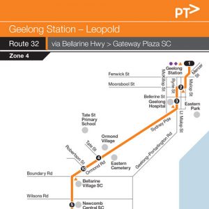
Route 32 travels between Geelong and Leopold via Ormond Rd, Bellarine Hwy, Gateway Shopping Centre, Estuary Estate and through Leopold. Route 56 – Geelong to Queenscliff via Ocean Grove also travels along Bellarine Hwy through Leopold. Route 61 – Geelong to Drysdale via Leopold & Clifton Springs travels along Bellarine Hwy to Leopold then through Dorothy Rd shops and along Christies Rd to Portarlington Rd. Route 60 – Geelong to St Leonards via Drysdale & Portarlington travels along Portarlington Rd through Leopold.


Route 32 – Geelong to Leopold

Departs from Geelong Station and travels via Railway Tce, Mercer St, Malop St, Moorabool St, Ryrie St, Sydney Pde. Ormond Rd, Bellarine Hwy, Melaluka Rd, Gateway Plaza , Melaluka Rd, Shoaling Dr, Ila Dr, Estuary Bvd, Melaluka Rd, Warrawee Rd, Ferguson Rd, Hazelwood Cr, Ash Rd, Bellarine Hwy, Kensington Rd, Highland Way, Christies Rd, Shortland Way to the terminus in Hoddle Dr at the corner of Hammer Ct, Leopold.


Route 32 – Leopold to Geelong

Departs from the Leopold terminus in Hoddle Dr at Hammer Ct and travels via Hoddle Dr, Pollard Dr, Christies Rd, Highland Way, Kensington Rd, Bellarine Hwy, Ash Rd, Hazelwood Cr, Ferguson Rd, Warrawee Rd, Melaluka Rd, Shoaling Dr, Ila Dr, Estuary Bvd, Melaluka Rd, Gateway Plaza Access Rd to Gateway Plaza and then via Melaluka Rd, Bellarine Hwy, Ormond Rd, Sydney Pde, Ryrie St, Moorabool St, Malop St, Mercer St and Railway Tce to Geelong Station.

Train Timetables


V/Line operate the train services between Melbourne and Geelong. The above link will open their web site in a new page. To find the Geelong train timetable, go to the timetables section.


Customers please note


Customers Tips

When using our services, we want you to be safe. Here are some tips that may assist you in making your trip more enjoyable.


  • Customer information tools

    There is a range of handy mobile and online tools available to help you access public transport information wherever you are in Victoria

  • Bus Safety

    There are a number of things that you can do to make your bus journey safer and more secure.

  • Travelling with Children

    Public transport is a fun and easy way to travel around Geelong with children. Children aged four years and under travel for free right across Victoria.
    When travelling with a pram, hold on to the pram and make sure your child is strapped in securely. Apply the brake to prevent it from rolling.

 amamamamamamam
Hoddle Drv @ Hammer Ct Leopold5:346:056:477:298:048:599:38
Ash Rd at The Court5:416:126:547:378:149:079:45
Gateway Plaza north bound5:556:267:077:548:309:209:59
Ormond Village opposite Cemetery6:056:367:188:078:459:3210:11
Geelong Station @ Bay 56:156:487:308:209:009:4510:25
        
 amamampmpmpmpm
Hoddle Drv @ Hammer Ct Leopold10:1610:5811:3912:2012:591:482:30
Ash Rd at The Court10:2311:0511:4612:271:061:552:37
Gateway Plaza north bound10:3711:1911:5912:411:202:082:51
Ormond Village opposite Cemetery10:4811:3012:1112:511:312:193:02
Geelong Station @ Bay 511:0111:4512:251:051:452:323:15
        
 pmpmpmpmpmpmpm
Hoddle Drv @ Hammer Ct Leopold3:074:034:175:126:116:387:53
Ash Rd at The Court3:144:104:245:206:186:458:00
Gateway Plaza north bound3:284:244:375:336:316:598:13
Ormond Village opposite Cemetery3:404:344:485:446:427:098:22
Geelong Station @ Bay 53:564:495:015:576:527:218:34
        
 pm
Hoddle Drv @ Hammer Ct Leopold8:50
Ash Rd at The Court8:57
Gateway Plaza north bound9:11
Ormond Village opposite Cemetery9:21
Geelong Station @ Bay 59:33
 amamamamamampm
Hoddle Drv @ Hammer Ct Leopold6:448:009:179:5611:1111:581:11
Ash Rd at The Court6:518:079:2410:0311:1912:051:18
Gateway Plaza north bound7:048:209:3810:1611:3312:191:32
Ormond Village opposite Cemetery7:138:319:4910:2811:4312:291:44
Geelong Station @ Bay 57:248:4310:0010:4112:0012:431:58
        
pmpmpmpm
Hoddle Drv @ Hammer Ct Leopold2:003:084:045:12
Ash Rd at The Court2:073:154:115:19
Gateway Plaza north bound2:213:284:255:33
Ormond Village opposite Cemetery2:313:404:355:44
Geelong Station @ Bay 52:443:534:475:55
 amamamampmpmpm
Hoddle Drv @ Hammer Ct Leopold8:429:5611:1111:581:112:003:08
Ash Rd at The Court8:4910:0411:1912:051:182:073:15
Gateway Plaza north bound9:0310:1611:3212:181:322:203:29
Ormond Village opposite Cemetery9:1410:2611:4412:291:442:313:40
Geelong Station @ Bay 59:2510:3711:5712:411:572:433:52
        
pm
Hoddle Drv @ Hammer Ct Leopold4:04
Ash Rd at The Court4:11
Gateway Plaza north bound4:24
Ormond Village opposite Cemetery4:35
Geelong Station @ Bay 54:45

Route Map


Latest News


Major Stops


Description of route


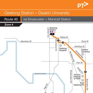
Route 40 travels between Geelong and Deakin University, Waurn Ponds via Ormond Rd, Breakwater, Belmont, Marshall Station, Grovedale and Waurn Ponds Shopping Centre. Route 41 – Geelong to Deakin University via Grovedale and Route 42 – Geelong to Deakin University via South Valley Rd also services similar areas in Grovedale.


Route 40 – Geelong to Deakin University, Waurn Ponds

Departs from Geelong Station and runs via Railway Tce, Mercer St, Malop St, Moorabool St, Ryrie St, Sydney Pde, Ormond Rd, Boundary Rd, Leather St, Tucker St, Breakwater Rd, Settlement Rd, Francis St, Roslyn Rd, Evans St, Torquay Rd, Surf Coast Hwy, Marshalltown Rd, Marshall Station, Marshalltown Rd, Bailey St, Reserve Rd, Burleigh Dr, Hansen Dr, Perrett St, Torquay Rd (Surf Coast Hwy), Heyers Rd, Burdoo Dr, Gloucester St, Pioneer Rd, Colac Rd, Pigdons Rd and Alfred Deakin Dr to Deakin University, Waurn Ponds.


Route 40 – Deakin University, Waurn Ponds to Geelong

Departs from Deakin University and runs via Alfred Deakin Dr, Pigdons Rd, Colac Rd, Pioneer Rd, Gloucester St, Burdoo Dr, Heyers Rd, Torquay Rd, Perrett St, Hansen Dr, Burleigh Dr, Reserve Rd, Bailey St, Marshalltown Rd, Marshall Station, Marshalltown Rd, Torquay Rd, Evans St, Roslyn Rd, Francis St, Settlement Rd, Breakwater Rd, Tucker St, Leather St, Boundary Rd, Ormond Rd, Sydney Pde, Ryrie St, Moorabool St, Malop St, Mercer St and Railway Tce to Geelong Station.

Train Timetables


V/Line operate the train services between Melbourne and Geelong. The above link will open their web site in a new page. To find the Geelong train timetable, go to the timetables section.


Customers please note


Customers Tips

When using our services, we want you to be safe. Here are some tips that may assist you in making your trip more enjoyable.


  • Customer information tools

    There is a range of handy mobile and online tools available to help you access public transport information wherever you are in Victoria

  • Bus Safety

    There are a number of things that you can do to make your bus journey safer and more secure.

  • Travelling with Children

    Public transport is a fun and easy way to travel around Geelong with children. Children aged four years and under travel for free right across Victoria.
    When travelling with a pram, hold on to the pram and make sure your child is strapped in securely. Apply the brake to prevent it from rolling.

 amamamamamampm
Deakin University Waurn Ponds5:557:017:368:4510:0711:0912:27
Waurn Ponds SC eastbound6:007:067:418:5110:1211:1512:32
Marshall Station6:167:227:599:0710:2811:3012:48
Leather St at Reeves Crt east bound6:327:398:179:2410:4511:471:05
Ormond Village opposite Cemetery6:387:458:239:3010:5111:531:11
Geelong Station @ Bay 116:487:598:399:4311:0512:071:25
        
 pmpmpmpmpmpm
Deakin University Waurn Ponds1:262:243:444:495:066:39
Waurn Ponds SC eastbound1:312:293:514:565:136:44
Marshall Station1:472:454:085:115:277:01
Leather St at Reeves Crt east bound2:043:024:285:305:447:16
Ormond Village opposite Cemetery2:103:104:355:355:507:22
Geelong Station @ Bay 112:243:244:485:476:037:32

Route Map


Major Stops


Description of route


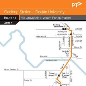
Route 41 travels between Geelong and Deakin University, Waurn Ponds via Belmont, Church St, Waurn Ponds Shopping Centre and Waurn Ponds Station. Route 40 – Geelong to Deakin University via Breakwater and Route 42 – Geelong to Deakin University via South Valley Rd also services similar areas in Grovedale.


Route 41 – Geelong to Deakin University, Waurn Ponds

Departs from Geelong Station and runs via Railway Tce, Mercer St, Malop St, Moorabool St, High St, Corio St, Torquay Rd, Church St, Pioneer Rd, Colac Rd, Rossack Dr, Bodega St and Sugargum Dr to Waurn Ponds Station; then via Sugargum Dr, Ghazeepore Rd, Colac Rd, Pigdons Rd and Alfred Deakin Dr to Deakin University,Waurn Ponds.


Route 41 – Deakin University, Waurn Ponds to Geelong

Departs from Deakin University, Waurn Ponds and runs via Alfred Deakin Dr, Pigdons Rd, Colac Rd, Ghazeepore Rd and Sugargum Dr to Waurn Ponds Station; then via Sugargum Dr, Bodega St, Rossack Dr, Colac Rd, Pioneer Rd, Church St, Torquay Rd, Corio St, High St, Moorabool St, Malop St, Mercer St and Railway Tce to Geelong Station.

Train Timetables


V/Line operate the train services between Melbourne and Geelong. The above link will open their web site in a new page. To find the Geelong train timetable, go to the timetables section.


Customers please note


Customers Tips

When using our services, we want you to be safe. Here are some tips that may assist you in making your trip more enjoyable.


  • Customer information tools

    There is a range of handy mobile and online tools available to help you access public transport information wherever you are in Victoria

  • Bus Safety

    There are a number of things that you can do to make your bus journey safer and more secure.

  • Travelling with Children

    Public transport is a fun and easy way to travel around Geelong with children. Children aged four years and under travel for free right across Victoria.
    When travelling with a pram, hold on to the pram and make sure your child is strapped in securely. Apply the brake to prevent it from rolling.

 amamamamamamam
Deakin University Waurn Ponds5:506:236:507:157:367:528:16
Waurn Ponds Station East bound5:586:316:587:237:448:008:24
Waurn Ponds SC eastbound6:056:397:067:317:528:088:32
Torquay Rd & Spring St Inbound6:156:497:167:428:048:208:44
Geelong Station @ Bay 116:287:027:317:588:208:389:03
        
amamamamamamam
Deakin University Waurn Ponds8:409:039:269:449:5910:4311:20
Waurn Ponds Station East bound8:479:119:349:5110:0710:5111:28
Waurn Ponds SC eastbound8:559:199:429:5910:1510:5911:36
Torquay Rd & Spring St Inbound9:059:299:5210:1110:2511:0911:46
Geelong Station @ Bay 119:239:4410:0810:2710:4111:2512:03
        
 ampmpmpmpmpmpm
Deakin University Waurn Ponds11:5812:531:412:272:593:193:46
Waurn Ponds Station East bound12:061:011:482:353:063:263:54
Waurn Ponds SC eastbound12:141:091:562:433:153:354:02
Torquay Rd & Spring St Inbound12:241:202:072:533:263:464:12
Geelong Station @ Bay 1112:411:372:233:103:444:044:30
        
 pmpmpmpmpmpmpm
Deakin University Waurn Ponds4:054:244:445:045:225:456:01
Waurn Ponds Station East bound4:134:314:525:125:295:536:09
Waurn Ponds SC eastbound4:214:395:005:205:386:016:16
Torquay Rd & Spring St Inbound4:314:495:105:305:476:116:26
Geelong Station @ Bay 114:475:065:275:466:026:256:40
        
 pmpmpmpm
Deakin University Waurn Ponds6:317:238:048:53
Waurn Ponds Station East bound6:397:308:108:59
Waurn Ponds SC eastbound6:467:378:179:06
Torquay Rd & Spring St Inbound6:567:478:279:16
Geelong Station @ Bay 117:108:018:419:28
 amamamamampmpm
Deakin University Waurn Ponds7:048:079:0110:0311:0412:071:07
Waurn Ponds Station East bound7:108:139:0710:0911:1012:131:13
Waurn Ponds SC eastbound7:178:209:1410:1711:1812:201:20
Torquay Rd & Spring St Inbound7:268:309:2410:2811:2912:301:30
Geelong Station @ Bay 117:418:449:4010:4611:4612:481:47
        
 pmpmpmpmpmpm
Deakin University Waurn Ponds2:073:054:075:076:087:07
Waurn Ponds Station East bound2:133:114:135:136:147:13
Waurn Ponds SC eastbound2:213:184:205:206:217:20
Torquay Rd & Spring St Inbound2:303:284:305:306:317:30
Geelong Station @ Bay 112:473:444:465:456:457:44
 amamampmpmpmpm
Deakin University Waurn Ponds9:0110:0311:0712:071:072:073:07
Waurn Ponds Station East bound9:0710:0911:1312:131:132:133:13
Waurn Ponds SC eastbound9:1410:1611:2012:211:202:213:20
Torquay Rd & Spring St Inbound9:2410:2711:3012:311:302:313:30
Geelong Station @ Bay 119:3910:4211:4612:461:442:453:45
        
 pmpm
Deakin University Waurn Ponds4:075:07
Waurn Ponds Station East bound4:135:13
Waurn Ponds SC eastbound4:205:20
Torquay Rd & Spring St Inbound4:305:30
Geelong Station @ Bay 114:445:44

Route Map


Latest News


Major Stops


Description of route


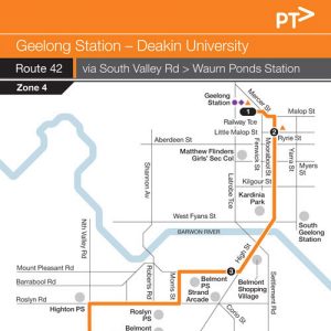
Route 42 travels between Geelong and Deakin University, Waurn Ponds via Belmont, South Valley Rd, Waurn Ponds Shopping Centre, Heyers Rd and Waurn Ponds Station. Route 41 – Geelong to Deakin University via Grovedale and Route 40 – Geelong to Deakin University via Breakwater also services similar areas in Grovedale.


Route 42 – Geelong to Deakin University, Waurn Ponds

Departs from Geelong Station and runs via Railway Tce, Mercer St, Malop St, Moorabool St, High St, Mt Pleasant Rd, Morris St, Roslyn Rd, South Valley Rd, Glastonbury Dr, Pioneer Rd, Burdoo Dr, Heyers Rd, Rossack Dr, Bodega St and Sugargum Dr to Waurn Ponds Station then via Sugargum Dr, Ghazeepore Rd, Colac Rd, Pigdons Rd and Alfred Deakin Dr to Deakin University, Waurn Ponds.


Route 42 – Deakin University, Waurn Ponds to Geelong

Departs from Deakin University, Waurn Ponds, and runs via Alfred Deakin Dr, Pigdons Rd, Colac Rd, Ghazeepore Rd, Sugargum Dr to Waurn Ponds Station then via Sugargum Dr, Bodega St, Rossack Dr, Heyers Rd, Burdoo Dr, Pioneer Rd, Glastonbury Dr, South Valley Rd, Roslyn Rd, Morris St, Mt Pleasant Rd, High St, Moorabool St, Malop St, Mercer St and Railway Tce to Geelong Station.

Train Timetables


V/Line operate the train services between Melbourne and Geelong. The above link will open their web site in a new page. To find the Geelong train timetable, go to the timetables section.


Customers please note


Customers Tips

When using our services, we want you to be safe. Here are some tips that may assist you in making your trip more enjoyable.


  • Customer information tools

    There is a range of handy mobile and online tools available to help you access public transport information wherever you are in Victoria

  • Bus Safety

    There are a number of things that you can do to make your bus journey safer and more secure.

  • Travelling with Children

    Public transport is a fun and easy way to travel around Geelong with children. Children aged four years and under travel for free right across Victoria.
    When travelling with a pram, hold on to the pram and make sure your child is strapped in securely. Apply the brake to prevent it from rolling.

 amamamamamamam
Deakin University Waurn Ponds5:406:276:447:087:357:558:14
Waurn Ponds Station East bound5:476:356:517:167:438:028:22
Waurn Ponds SC Westbound5:556:447:007:257:528:138:32
Highton Roslyn Rd East Bound6:026:527:077:348:028:248:42
Mt Pleasant Rd & High St Inbound6:096:587:147:408:108:328:51
Geelong Station @ Bay 116:197:087:277:538:238:459:04
        
 amamamamamamam
Deakin University Waurn Ponds8:439:039:239:4010:0210:2010:42
Waurn Ponds Station East bound8:519:119:319:4710:0910:2710:50
Waurn Ponds SC Westbound9:019:219:419:5710:1810:3610:59
Highton Roslyn Rd East Bound9:099:299:4910:0410:2510:4411:06
Mt Pleasant Rd & High St Inbound9:179:359:5610:1210:3210:5111:13
Geelong Station @ Bay 119:319:4910:0910:2610:4511:0311:25
        
 amamampmpmpmpm
Deakin University Waurn Ponds10:5511:1711:3612:0212:2312:451:06
Waurn Ponds Station East bound11:0311:2511:4412:0912:3012:521:14
Waurn Ponds SC Westbound11:1211:3411:5312:1812:391:011:23
Highton Roslyn Rd East Bound11:2011:4212:0112:2712:481:101:31
Mt Pleasant Rd & High St Inbound11:2611:4812:1012:3312:541:171:37
Geelong Station @ Bay 1111:3812:0012:2312:451:061:301:49
        
 pmpmpmpmpmpmpm
Deakin University Waurn Ponds1:251:442:052:262:453:063:27
Waurn Ponds Station East bound1:331:522:132:342:533:143:34
Waurn Ponds SC Westbound1:422:012:222:433:023:233:44
Highton Roslyn Rd East Bound1:492:082:302:503:093:313:54
Mt Pleasant Rd & High St Inbound1:562:152:372:573:163:394:02
Geelong Station @ Bay 112:082:272:503:123:283:534:14
        
 pmpmpmpmpmpmpm
Deakin University Waurn Ponds3:474:074:294:515:075:375:56
Waurn Ponds Station East bound3:554:154:364:585:145:446:04
Waurn Ponds SC Westbound4:044:244:455:075:235:536:13
Highton Roslyn Rd East Bound4:124:324:535:155:316:016:20
Mt Pleasant Rd & High St Inbound4:204:394:595:225:376:076:26
Geelong Station @ Bay 114:334:525:115:345:506:196:38
        
 pmpmpmpmpmpmpm
Deakin University Waurn Ponds6:116:387:007:468:35
Waurn Ponds Station East bound6:186:457:087:548:42
Waurn Ponds SC Westbound6:276:537:168:028:50
Highton Roslyn Rd East Bound6:347:007:238:098:58
Mt Pleasant Rd & High St Inbound6:407:077:298:149:03
Geelong Station @ Bay 116:527:197:418:269:13
 amamamamampmpm
Deakin University Waurn Ponds7:248:269:1610:2411:2212:271:27
Waurn Ponds Station East bound7:308:329:2210:3011:2812:331:33
Waurn Ponds SC Westbound7:398:419:3110:4011:3712:421:42
Highton Roslyn Rd East Bound7:468:499:4010:4711:4512:501:50
Mt Pleasant Rd & High St Inbound7:528:559:4710:5611:5412:571:57
Geelong Station @ Bay 118:049:069:5811:0912:061:092:08
        
 pmpmpmpmpmpmpm
Deakin University Waurn Ponds2:283:274:255:276:307:278:28
Waurn Ponds Station East bound2:343:334:315:336:367:338:34
Waurn Ponds SC Westbound2:443:424:405:426:447:418:43
Highton Roslyn Rd East Bound2:523:504:485:496:527:498:50
Mt Pleasant Rd & High St Inbound2:593:564:545:556:587:548:56
Geelong Station @ Bay 113:104:085:056:077:108:059:07
amamampmpmpmpm
Deakin University Waurn Ponds9:1610:2411:2212:271:272:273:24
Waurn Ponds Station East bound9:2210:3011:2812:331:332:333:30
Waurn Ponds SC Westbound9:3110:3911:3712:421:422:423:38
Highton Roslyn Rd East Bound9:3910:4811:4512:501:492:503:46
Mt Pleasant Rd & High St Inbound9:4610:5411:5212:561:562:563:53
Geelong Station @ Bay 119:5811:0612:041:072:073:074:05
        
 pmpm
Deakin University Waurn Ponds4:275:27
Waurn Ponds Station East bound4:335:33
Waurn Ponds SC Westbound4:425:42
Highton Roslyn Rd East Bound4:505:50
Mt Pleasant Rd & High St Inbound4:565:56
Geelong Station @ Bay 115:076:06

Route Map


Latest News


Major Stops


Description of route

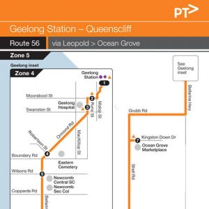
Route 56 travels between Geelong and Queenscliff via Bellarine Hwy, Ocean Grove and Point Lonsdale. Route 32 – Geelong to Leopold and Route 61 – Geelong to Drysdale via Leopold & Clifton Springs also services along Bellarine Hwy to Leopold. Route 55 – Geelong to Ocean Grove via Barwon Heads also services Ocean Grove.

Route 56 – Geelong to Queenscliff

Departs from Geelong Station and runs via Railway Tce, Mercer St, Malop St, Moorabool St, Ryrie St, Sydney Pde, Ormond Rd, Bellarine Hwy, Melaluka Rd, Gateway Plaza Access Rd, Melaluka Rd, Bellarine Hwy, Grubb Rd, Shell Rd, Fellows Rd, Ocean Rd, Point Lonsdale Rd, Queenscliff Rd (Bellarine Hwy), Flinders St, Bethune St, King St, Hesse St and Wharf St to Queenscliff Ferry Terminal.

Route 56 – Queenscliff to Geelong

Departs from Queenscliff Ferry Terminal and runs via Wharf St, Hesse St, King St, Bethune St, Flinders St, Queenscliff Rd (Bellarine Hwy), Point Lonsdale Rd, Ocean Rd, Fellows Rd, Shell Road, Grubb Rd, Bellarine Hwy, Melaluka Rd, Gateway Plaza Access Rd, Melaluka Rd, Bellarine Hwy, Ormond Rd, Sydney Pde, Ryrie St, Moorabool St, Malop St, Mercer St and Railway Tce to Geelong Station.

Train Timetables


V/Line operate the train services between Melbourne and Geelong. The above link will open their web site in a new page. To find the Geelong train timetable, go to the timetables section.


Customers please note


  • Buses operate to a Saturday timetable on public holidays except Christmas Day and Good Friday when a Sunday timetable shall apply.

  • From time to time, bus schedules may change or be delayed without notice due to unforeseen circumstance

Customers Tips

When using our services, we want you to be safe. Here are some tips that may assist you in making your trip more enjoyable.


  • Customer information tools

    There is a range of handy mobile and online tools available to help you access public transport information wherever you are in Victoria

  • Bus Safety

    There are a number of things that you can do to make your bus journey safer and more secure.

  • Travelling with Children

    Public transport is a fun and easy way to travel around Geelong with children. Children aged four years and under travel for free right across Victoria.
    When travelling with a pram, hold on to the pram and make sure your child is strapped in securely. Apply the brake to prevent it from rolling.

amamamamamampm
Queenscliff Harbour5:226:067:138:509:5411:551:55
Point Lonsdale Bowling Club5:316:167:259:0210:0512:072:06
Ocean Grove Market Place5:436:307:399:1610:2012:212:20
Bellarine Secondary Ocean Grove
Gateway Plaza north bound6:006:488:009:3510:3812:412:40
Ormond Village opposite Cemetery6:086:588:129:4510:4912:512:51
Geelong Station @ Bay 56:177:088:2910:0011:031:063:05
        
pmpmpmpmpm
Queenscliff Harbour2:594:005:176:588:43
Point Lonsdale Bowling Club3:104:115:287:098:54
Ocean Grove Market Place3:244:265:427:239:08
Bellarine Secondary Ocean Grove3:28
Gateway Plaza north bound3:494:455:597:399:24
Ormond Village opposite Cemetery4:024:566:107:489:33
Geelong Station @ Bay 54:195:106:228:009:43
 amamamampmpmpm
Queenscliff Harbour7:058:169:3310:5212:161:393:00
Point Lonsdale Bowling Club7:168:289:4611:0412:281:513:13
Ocean Grove Market Place7:288:419:5911:1912:412:043:26
Gateway Plaza north bound7:438:5710:1811:3912:572:213:45
Ormond Village opposite Cemetery7:539:0810:2911:521:102:333:55
Geelong Station @ Bay 58:039:2210:4412:051:232:474:07
        
 pmpmpm
Queenscliff Harbour4:205:456:49
Point Lonsdale Bowling Club4:325:567:00
Ocean Grove Market Place4:446:087:12
Gateway Plaza north bound5:016:257:29
Ormond Village opposite Cemetery5:116:357:41
Geelong Station @ Bay 55:236:477:52
 amamampmpmpmpm
Queenscliff Harbour8:199:3410:5212:161:383:004:20
Point Lonsdale Bowling Club8:329:4711:0312:291:503:134:33
Ocean Grove Market Place8:449:5911:1812:412:043:254:44
Gateway Plaza north bound9:0010:1711:3812:592:213:445:00
Ormond Village opposite Cemetery9:1110:2811:501:112:343:565:12
Geelong Station @ Bay 59:2310:4312:051:252:474:065:26
        
 pm
Queenscliff Harbour5:45
Point Lonsdale Bowling Club5:56
Ocean Grove Market Place6:08
Gateway Plaza north bound6:25
Ormond Village opposite Cemetery6:35
Geelong Station @ Bay 56:47

Route Map


Major Stops


Description of route

Route 61 travels between Geelong and Drysale via Leopold and Clifton Springs. Route 60 – Geelong to St Leonards via Drysdale & Portarlington also services between Geelong and Drysdale via Portarlington Rd. Bellarine Hwy and then does the Leopold loop. Route 32 – Geelong to Leopold also services Leopold via Bellarine Hwy. Route 56 – Geelong to Queenscliff via Ocean Grove also services Bellarine Hwy.

Route 61 – Geelong to Drysdale

Departs Geelong Station and runs via Railway Tce, Mercer St, Malop St, Moorabool St, Ryrie St, Sydney Pde, Ormond Rd, Queenscliff Rd (Bellarine Hwy), Melaluka Rd, Gateway Plaza, Melaluka Rd, Queenscliff Rd (Bellarine Hwy), Simons Rd, Dorothy St, Christies Rd, Drysdale Rd (Portarlington Rd), Jetty Rd, Centennial Bvd (Curlewis Shopping Centre),Jetty Rd, Bay Shore Av, Beacon Pt Rd, Dandarriga Dr, Narawi Av, Thamballina Rd, Beacon Pt Rd, Clifton Springs Rd and High St (Portarlington Rd) to Drysdale Village Shopping Centre in High St at the corner of Eversley St, Drysdale.

Route 61 – Drysdale to Geelong

Departs Drysdale terminus in High St and runs via High St (Portarlington Rd), Clifton Springs Rd, Beacon Pt Rd, Thamballina Rd, Narawi Av, Dandarriga Dr, Beacon Pt Rd, Bay Shore Av, Jetty Rd, Centennial Bvd (Curlewis Shopping Centre), Jetty Rd, Drysdale Rd (Portarlington Rd), Christies Rd, Dorothy St, Simons Rd, Queenscliff Rd (Bellarine Hwy), Melaluka Rd, Gateway Plaza, Melaluka Rd, Queenscliff Rd (Bellarine Hwy), Ormond Rd, Sydney Pde, Ryrie St, Moorabool St, Malop St, Mercer St and Railway Tce to Geelong Station.

Train Timetables


V/Line operate the train services between Melbourne and Geelong. The above link will open their web site in a new page. To find the Geelong train timetable, go to the timetables section.


Customers please note


Customers Tips

When using our services, we want you to be safe. Here are some tips that may assist you in making your trip more enjoyable.


  • Customer information tools

    There is a range of handy mobile and online tools available to help you access public transport information wherever you are in Victoria

  • Bus Safety

    There are a number of things that you can do to make your bus journey safer and more secure.

  • Travelling with Children

    Public transport is a fun and easy way to travel around Geelong with children. Children aged four years and under travel for free right across Victoria.
    When travelling with a pram, hold on to the pram and make sure your child is strapped in securely. Apply the brake to prevent it from rolling.

amamamamamamam
Drysdale Shops Nth bound5:446:126:587:548:299:029:42
Curlewis Shopping Centre Greenvale Dr6:016:297:168:128:489:199:59
Christies Rd opposite Highland Way6:116:407:268:279:009:2910:10
Gateway Plaza north bound6:186:477:348:369:089:3710:18
Ormond Village opposite Cemetery6:276:587:458:489:219:4710:28
Geelong Station @ Bay 66:377:088:029:059:3710:0310:43
        
amamampmpmpmpm
Drysdale Shops Nth bound10:2211:0011:411:081:412:213:50
Curlewis Shopping Centre Greenvale Dr10:3911:1711:581:251:582:384:07
Christies Rd opposite Highland Way10:4911:2812:081:352:102:484:17
Gateway Plaza north bound10:5711:3612:161:422:182:554:25
Ormond Village opposite Cemetery11:0811:4712:271:532:293:064:36
Geelong Station @ Bay 611:2312:0112:432:082:423:214:52
        
pmpmpmpm
Drysdale Shops Nth bound5:065:567:197:59
Curlewis Shopping Centre Greenvale Dr5:246:137:368:16
Christies Rd opposite Highland Way5:356:237:468:26
Gateway Plaza north bound5:426:307:538:32
Ormond Village opposite Cemetery5:536:408:028:41
Geelong Station @ Bay 66:086:508:128:51
amamamampmpmpm
Drysdale Shops Nth bound7:079:0810:2311:431:052:254:03
Curlewis Shopping Centre Greenvale Dr7:249:2510:4012:011:232:414:19
Christies Rd opposite Highland Way7:349:3510:5212:141:372:524:29
Gateway Plaza north bound7:419:4411:0012:221:453:004:37
Ormond Village opposite Cemetery7:519:5511:1312:331:563:104:47
Geelong Station @ Bay 68:0210:1011:2712:472:103:275:03
        
pmpmpm
Drysdale Shops Nth bound5:076:437:59
Curlewis Shopping Centre Greenvale Dr5:246:598:15
Christies Rd opposite Highland Way5:367:098:25
Gateway Plaza north bound5:427:168:32
Ormond Village opposite Cemetery5:537:278:42
Geelong Station @ Bay 66:067:378:53
 amamampmpmpmpm
Drysdale Shops Nth bound9:0010:2311:441:052:254:055:07
Curlewis Shopping Centre Greenvale Dr9:1610:4012:031:232:424:215:24
Christies Rd opposite Highland Way9:2810:5012:161:362:524:315:34
Gateway Plaza north bound9:3610:5912:231:442:594:395:41
Ormond Village opposite Cemetery9:4611:1112:341:553:104:495:52
Geelong Station @ Bay 610:0011:2512:462:083:255:036:05
        
 pm
Drysdale Shops Nth bound6:43
Curlewis Shopping Centre Greenvale Dr7:00
Christies Rd opposite Highland Way7:10
Gateway Plaza north bound7:17
Ormond Village opposite Cemetery7:26
Geelong Station @ Bay 67:37

Route Map


Major Stops


Description of route


There are some minor changes to Route 60 timetable commencing  in June 2024, to allow for improve connections to Portarlington Ferry and services at Geelong Rail.

Route 60 travels between Geelong and St Leonards via Drysdale and Portarlington. Route 61 – Geelong to Drysdale via Leopold & Clifton Springs also services between Geelong and Drysdale via Leopold and Clifton Springs. Route 32 – Geelong to Leopold also services Leopold near Portarlington Rd.


Route 60 – Geelong to St Leonards

via Leopold, Drysdale Portarlington

Departs from Geelong Station and travels via Railway Tce, Mercer St, Malop St, Moorabool St, Ryrie St, Drysdale Rd (Portarlington Rd), High St, Collins St, Portarlington Rd, Newcombe St, Fisher St, Stevens St, Gellibrand St, Newcombe St, Mercer St, The Esplanade, Hood Rd, Henderson St, Batman Rd, The Esplanade, Murradoc Rd (Drysdale-St Leonards Rd), Cole St, Sandbar St, Mainsail Dr, Bluff Rd and Leviens Rd.

PLEASE NOTE: A number of services to St Leonards terminate after the St Leonards Loop (Bluff Rd, Mainsail Dr, Sandbar St, Seachange Way) at the corner of Clyde Av and Seachange Way.

  • 60 – Geelong Station to Drysdale, weekday direct service
    • Departs from Geelong Station and travels via Railway Tce, Mercer St, Malop St, Moorabool St, Ryrie St and Drysdale Rd to High St, Drysdale Village Shopping Centre.
  • 60A – Drysdale to St Leonards, weekday service
    • Departs from Drysdale Village SC and travels via High St, Collins St, Portarlington Rd, Newcombe St, Fisher St, Stevens St, Gellibrand St, Newcombe St, Mercer St, The Esplanade, Hood Rd, Henderson St, Batman Rd, The Esplanade, Murradoc Rd (Drysdale-St Leonards Rd), Cole St, Seachange Way, Gilbert St to the terminus at the corner of Bluff Rd, St Leonards.

Route 60 – St Leonards to Geelong

Departs from Leviens Rd, near the corner of Bluff St at Stop No. 27584, and travels via Bluff Rd, Mainsail Dr, Sandbar St, Seachange Way, Leviens Rd, Murradoc Rd (Drysdale-St Leonards Rd), The Esplanade, Batman Rd, Henderson St, Hood Rd, The Esplanade, Mercer St, Newcombe St, Gellibrand St, Stevens St, Fisher St, Newcombe St, Portarlington Rd, Collins St, High St. Drysdale Rd (Portarlington Rd), Ryrie St, Moorabool St, Malop St, Mercer St and Railway Tce to Geelong Station. NOTE: Weekday direct service from Drysdale to Geelong Station via Leopold: Departs Drysdale Village Shopping Centre and travel via High St, Drysdale Rd, Ryrie St, Moorabool St, Malop St, Mercer St, Railway Tce to Geelong Station.

  • 60 – Drysdale to Geelong Station, weekday direct service
    • Departs from Drysdale Shopping Centre and travels via High St, Drysdale Rd, Ryrie St, Moorabool St, Malop St, Mercer St, Railway Tce to Geelong Station.
  • 60A – St Leonards to Drysdale, weekday service
    • Departs from Leviens Rd near corner of Bluff St at stop  and runs via Bluff Rd, Mainsail Dr, Sandbar St, Seachange Way, Leviens Rd, Murradoc Rd (Drysdale-St Leonards Rd), The Esplanade, Batman Rd, Henderson St, Hood Rd, The Esplanade, Mercer St, Newcombe St, Gellibrand St, Stevens St, Fisher St, Newcombe St, Portarlington Rd, Collins St and High St to the terminus at Drysdale Village SC.

Train Timetables


V/Line operate the train services between Melbourne and Geelong. The above link will open their web site in a new page. To find the Geelong train timetable, go to the timetables section.


Customers please note


Customers Tips

When using our services, we want you to be safe. Here are some tips that may assist you in making your trip more enjoyable.


  • Customer information tools

    There is a range of handy mobile and online tools available to help you access public transport information wherever you are in Victoria

  • Bus Safety

    There are a number of things that you can do to make your bus journey safer and more secure.

  • Travelling with Children

    Public transport is a fun and easy way to travel around Geelong with children. Children aged four years and under travel for free right across Victoria.
    When travelling with a pram, hold on to the pram and make sure your child is strapped in securely. Apply the brake to prevent it from rolling.

 amamamamamamam
St Leonards Leviens Rd facing Bluff Rd5:235:416:116:568:249:13
Indented Head Inbound5:375:556:267:118:399:27
Portarlington Inbound5:496:076:397:288:549:40
Drysdale Shops Sth bound6:026:206:567:418:319:109:53
Portarlington Rd @ Christies Rds6:136:307:057:508:439:2010:02
Ryrie St & Fitzroy St6:236:417:198:088:579:3410:17
Geelong Station @ Bay 66:276:487:298:199:059:4510:25
 amamam ampmpmpm
St Leonards Leviens Rd facing Bluff Rd9:5310:3011:1311:5212:351:141:53
Indented Head Inbound10:0710:4311:2712:0612:491:282:07
Portarlington Inbound10:2010:5511:3912:181:011:412:20
Drysdale Shops Sth bound10:3311:0811:5212:311:151:552:34
Portarlington Rd @ Christies Rds10:4311:1912:0212:411:262:042:43
Ryrie St & Fitzroy St10:5711:3412:1712:561:382:172:56
Geelong Station @ Bay 611:0511:4312:2513:051:462:253:05
 pmpmpmpmpmpmpm
St Leonards Leviens Rd facing Bluff Rd3:564:326:417:46
Indented Head Inbound4:094:466:528:00
Portarlington Inbound4:224:587:058:12
Drysdale Shops Sth bound3:574:355:116:007:167:558:25
Portarlington Rd @ Christies Rds4:054:455:216:097:268:058:35
Ryrie St & Fitzroy St4:194:575:336:207:388:168:45
Geelong Station @ Bay 64:285:075:416:267:458:228:51

 amamamampmpmpm
St Leonards Leviens Rd facing Bluff Rd6:568:149:3010:5012:121:332:57
Indented Head Inbound7:108:289:4511:0512:291:503:11
Portarlington Inbound7:238:4110:0011:2012:432:043:24
Drysdale Shops Sth bound7:368:5410:1511:3412:572:163:36
Portarlington Rd @ Christies Rds7:469:0410:2611:441:082:283:47
Ryrie St & Fitzroy St7:569:1610:3811:571:212:383:58
Geelong Station @ Bay 68:029:2510:4512:051:272:454:05
        
 pmpmpm
St Leonards Leviens Rd facing Bluff Rd4:155:316:47
Indented Head Inbound4:295:457:01
Portarlington Inbound4:415:577:13
Drysdale Shops Sth bound4:546:107:26
Portarlington Rd @ Christies Rds5:046:207:35
Ryrie St & Fitzroy St5:156:317:46
Geelong Station @ Bay 65:216:377:52
 amamampmpmpmpm
St Leonards Leviens Rd facing Bluff Rd8:189:3210:5012:111:332:554:13
St Leonards Shops8:259:4010:5912:201:423:024:20
Indented Head Inbound8:329:4711:0612:281:503:094:27
Portarlington Inbound8:4510:0011:2012:422:033:224:40
Drysdale Shops Sth bound8:5810:1411:3412:572:163:354:52
Portarlington Rd @ Christies Rds9:0710:2411:441:052:243:455:02
Ryrie St & Fitzroy St9:1810:3611:571:182:363:565:14
Geelong Station @ Bay 69:2410:4512:051:262:454:035:21
        
 pm
St Leonards Leviens Rd facing Bluff Rd5:29
St Leonards Shops5:36
Indented Head Inbound5:43
Portarlington Inbound5:55
Drysdale Shops Sth bound6:08
Portarlington Rd @ Christies Rds6:19
Ryrie St & Fitzroy St6:30
Geelong Station @ Bay 66:37